Life

Dunes to neighborhoods: Historic aerial photos show San Francisco’s transformation

An aerial view of San Francisco’s Outer Sunset district in 2022, left, and in 1938, right.
Aerial views show San Francisco’s Outer Sunset district in 1938, left, and in 2022, right. | Source: Courtesy SF Planning

The ink is drying on new laws to streamline building in San Francisco, developers are eyeing bargain-priced Downtown real estate and a towering new skyscraper is already in the works. There’s no telling how the city’s skyline will be transformed in the coming decades. 

That makes this an apt moment to look back at how much the City by the Bay has evolved throughout the 20th and 21st centuries.

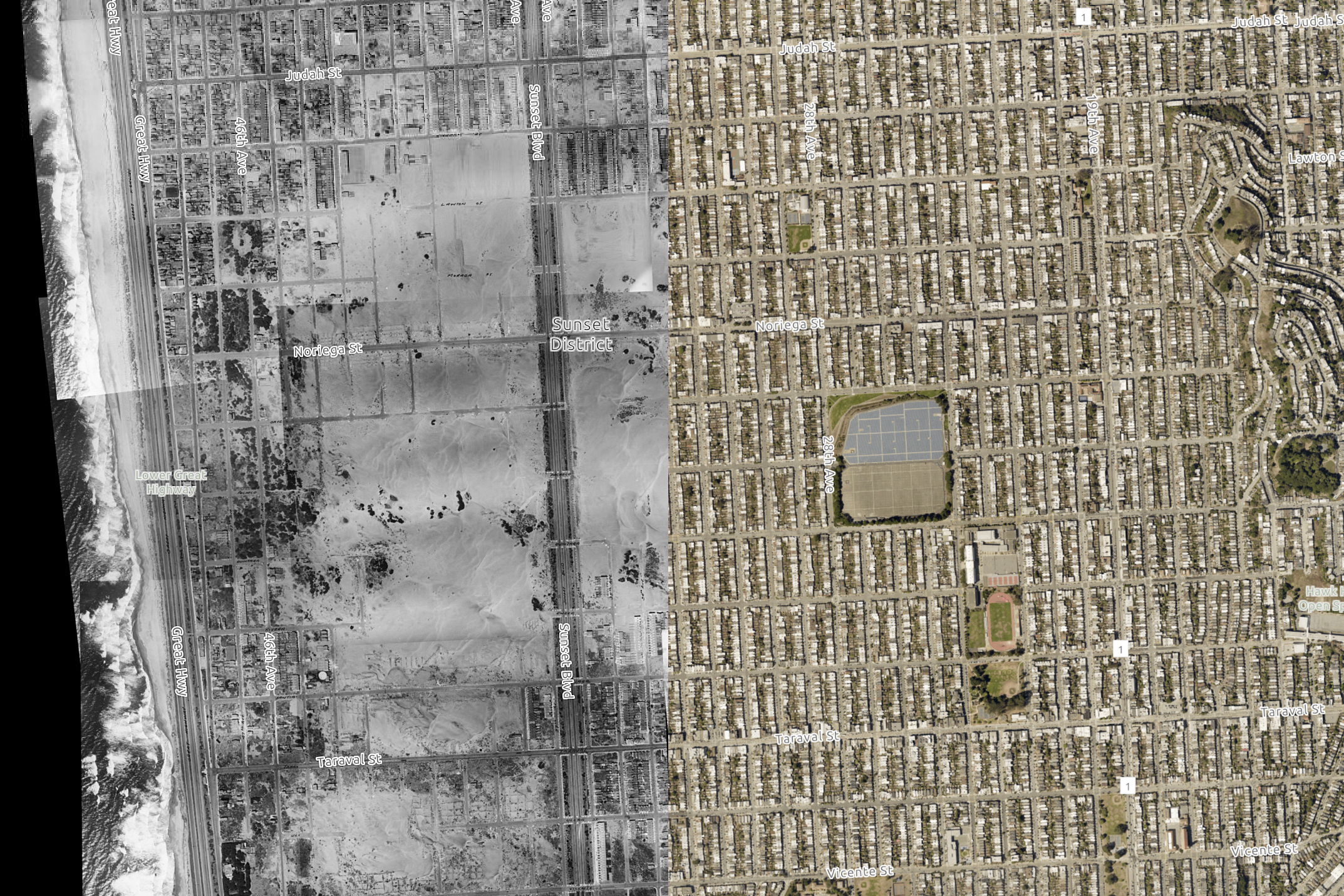
Side-by-side historic aerial photographs owned by the San Francisco Public Library and published online by the city’s Planning Department illustrate how dramatically the city has changed in the past 85 years. 

It’s like a bird's-eye view of San Francisco through a time machine. Over the years, highways replace avenues, world-famous stadiums rise in industrial zones and new homes grow out of the sand dunes.

An aerial view of the residential area in San Francisco’s Outer Sunset in 1938.An aerial view of the residential area in San Francisco’s Outer Sunset in 2022.
Drag to compare
Press left and right to compare
A 1938 aerial view, left, of the residential area in San Francisco’s Outer Sunset district includes swaths of sand dunes between the Lower Great Highway on the west, Funston Avenue on the east, Judah Street on the north and Vicente Street. The same area is shown in 2022, right. | Courtesy SF Planning

San Francisco’s sand dunes used to stretch well east of Ocean Beach. In fact, the aerial images from 1938 show that during that time, the dunes climbed as far east as 25th Avenue, nearly a mile and a half from the coast.

Before San Francisco became a destination during the gold rush, the San Francisco Peninsula was covered in at least a dozen square miles of sand dunes, according to the Exploratorium. Large areas of bare sand on the western side of the peninsula were regularly blown east by winds coming off the Pacific Ocean, building massive dunes where Downtown stands now. As the city grew, people used steam shovels to dig the sand, hauled it using railroad cars to the shoreline and dumped it into the shallow waters of the bay, creating new land.

Photos published on the San Francisco Municipal Transportation Agency blog show that in 1904, huge dunes stretched south from Golden Gate Park. And in 1910, the city used specialized streetcars to gather sand from the dunes. 

Over time, the expansive sand dunes were swallowed by the side-by-side houses filling the Sunset neighborhood.

An aerial view of the sparsely populated area around Twin Peaks and Clarendon Ave. in San Francisco in 1938An aerial view of the neighborhood atop Twin Peaks along Clarendon Ave. near Sutro Towers in San Francisco in 2022.
Drag to compare
Press left and right to compare
Aerial views show the sparsely populated area around Twin Peaks and Clarendon Avenue in San Francisco in 1938, left, and the area in 2022, right, which includes housing and new streets in the area. | Courtesy SF Planning

The 1938 aerial photos were taken in August of that year by Harrison Ryker, whose name was almost certainly incorrectly spelled in handwriting on the archival index sheet as Harrison-Rikker, according to the metadata accompanying the documents. Ryker was a photographer who worked with pilots flying out of the Oakland airport, and he also photographed the devastating 1923 Berkeley fire. He went on to develop a series of visual technologies, including stereoscopes and map plotters, that are now used in libraries and air photo collections across the country. He died in 1981.

The digitized 1938 photos are a composite set of 164 separate photographs, according to the metadata.

An aerial view of the Lake Merced surrounding farmlands in San Francisco in 1938.An aerial view of the Lake Merced Golf Course and surrounding residential neighborhoods in San Francisco in 2022.
Drag to compare
Press left and right to compare
Aerial views show the golf course at Lake Merced and surrounding farmlands in 1938, left, and the updated golf course and surrounding residential neighborhoods in 2022. | Courtesy SF Planning

The images in this article show side-by-side comparisons of a dozen locations in San Francisco, a sampling of what can be viewed in the original collection.

Farmland spread out east of Lake Merced, in San Francisco’s southwest, into the 1930s, the images show. At that time, the area had already been transformed into the golfer’s mecca that it is today. The lake was bordered by multiple courses, including the Lake Merced Golf Course—first erected in 1923—and the Harding Park Golf Course—which opened in 1925.

Vegetable farms stood on the edge of the lake in 1903, according to an archival newspaper article dug up by the Western Neighborhoods Project. An on-the-ground photo from 1937 published by Found SF shows a road running alongside the lake hemmed by knots of trees and bordered by the Fleishhacker Zoo.

An aerial view of the China Basin area of in San Francisco’s SoMa district in 1938 which includes the King and 3rd Streets which later became the location for the San Francisco Giants baseball park.An aerial view of China Basin area in San Francisco’s SoMa District in 2022 which includes the King and 3rd Streets which is the location for the San Francisco Giants baseball park.
Drag to compare
Press left and right to compare
Aerial views show the China Basin area in San Francisco’s SoMa District in 1938, left, and 2022, right, which is the location for the San Francisco Giants Oracle Park. | Courtesy SF Planning

San Francisco’s now-iconic bayside Oracle Park baseball stadium did not exist in 1938. Construction on the building wouldn’t begin for another 60 years.

An aerial view of the area around 3rd Street and 16th Street in San Francisco’s Mission Bay district in 1938.An aerial view of the area around 3rd Street and 16th Street which includes Chase Center, the home of the Golden State Warriors in San Francisco’s Mission Bay district in 2022.
Drag to compare
Press left and right to compare
Aerial views show the industrial area around Third Street in San Francisco 1938, left, and the area in 2022, which now includes the Chase Center, the home of the Golden State Warriors. | Courtesy SF Planning

The Chase Center, home of the Golden State Warriors, was also nonexistent at the time the historic images were captured. The storied Kezar Stadium out in the Sunset District, however, did stand tall at that time. First opened in 1925, the stadium initially hosted college football games before becoming the first home of the San Francisco 49ers in 1946, according to the team. The 49ers left Kezar Stadium for good in 1970, and the original amphitheater was eventually demolished, though athletic facilities still stand at the location in the southeast of Golden Gate Park.

An aerial view of Kezar Stadium in San Francisco in 1938.An aerial view of Kezar Stadium in San Francisco in 2022.
Drag to compare
Press left and right to compare
Aerial views show Kezar Stadium in San Francisco in 1938, left and 2022, right. Kezar Stadium was the home to the San Francisco 49ers from 1946 to 1970. | Courtesy SF Planning

The aerial images also reflect San Francisco’s long military history. Crissy Field was once a U.S. Army airfield.

An aerial view of Crissy Airfield in San Francisco in 1938An aerial view of Crissy Field, Battery Tunnel, Highway 101 and Tunnel Tops Park in San Francisco in 2022.
Drag to compare
Press left and right to compare
Aerial views show Crissy Airfield in San Francisco in 1938, left, and Crissy Field in 2022, right. Crissy Airfield was established as a U.S. Army Airfield in 1919, according to the National park Service. | Courtesy SF Planning

Hunters Point, meanwhile, grew significantly in the past 85 years, the images show. In 1938, the point was still being used as a commercial dry dock facility, according to the U.S. Navy. The next year, the Navy bought the land, ushering in 30 years of use as a shipyard repair facility and radiological defense laboratory. The navy closed the base in the ’90s.

An aerial view of the Hunters Point between India Basin and South Basin in San Francisco in 1938.An aerial view of the Hunters Point between India Basin and South Basin in San Francisco in 2022.
Drag to compare
Press left and right to compare
Aerial views show the Hunters Point between India Basin and South Basin in San Francisco in 1938, left, and 2022, right. | Courtesy SF Planning

Other parts of the city’s waterfront retracted during the 20th century, including surrounding the Bay Bridge, where a dense series of docks to the north no longer exist.

An aerial view of the Oakland-San Francisco Bay Bridge and a number of piers along The Embarcadero in 1938.An aerial view of the Oakland-San Francisco Bay Bridge along The Embarcadero in 2022.
Drag to compare
Press left and right to compare
Aerial views show the Oakland-San Francisco Bay Bridge and a number of piers along the Embarcadero in 1938, left, and the same area without the piers and expanded waterfront area in 2022. | Courtesy SF Planning

The images also show how San Franciscans spent their leisure time over the years. In 1938, the Sutro Baths, a unique public bathhouse, still stood in the city’s northwest.

An aerial view of Sutro Baths, the Cliff House and Point Lobos Ave. just north of Ocean Beach in San Francisco in 1938.An aerial view of the former locations of Sutro Baths, the Cliff House and Point Lobos Ave. just north of Ocean Beach in San Francisco in 2022.
Drag to compare
Press left and right to compare
Aerial views show Sutro Baths, the Cliff House and Point Lobos Avenue, north of Ocean Beach in San Francisco in 1938, left, and the same area with the remains and footprint of Sutro Baths, parking lots and expanding housing to the east as seen in 2022. | Courtesy SF Planning

And Golden Gate Park has stood as a natural oasis for residents since 1870.

An aerial view of Golden Gate Park along John F. Kennedy Drive at Conservatory Drive in 1938.An aerial view of people enjoying Golden Gate Park along John F. Kennedy Drive at Conservatory Drive in 2022.
Drag to compare
Press left and right to compare
Aerial views show an empty field at Golden Gate Park along John F. Kennedy Drive at Conservatory Drive in 1938, left, and the same area with a large group of people enjoying an event in 2022, right. | Courtesy SF Planning

From the gold rush to the tech boom, San Francisco has constantly remade itself throughout history. In 1938, the Central Freeway did not exist. Erected in 1959 to connect Highway 101 to Market Street, momentum is now picking up around its possible removal. It’s just one of countless parts of the cityscape that may shift in the next 85 years.

An aerial view of where above Division and Potrero Streets in 1938 which later became the location where US-101 & I-80 highway would intersect.An aerial view of where US-101 & I-80 meet in the SoMa neighborhood hoof of San Francisco in 2022
Drag to compare
Press left and right to compare
An aerial view shows Division Street and Potrero Avenue in 1938. Later, the intersection of U.S. Highway 101 and Interstate 80 highway was built over that location, as seen in 2022. This section of Highway 101 is known as the Central Freeway. | Courtesy SF Planning

Noah Baustin can be reached at nbaustin@sfstandard.com